Connect a data source
A map in Groundwork is a connection to one data source, plus the configuration that you add to it. You choose the source once, when you create the map. To connect to a different source, create another map.
Create the map
- Click the map name at the top of the right-hand panel.
- Choose Create new map.
Groundwork opens a page that shows the demo maps as cards under Try a demo. Below them, the data sources are tiles under Or connect your own data. Groundwork creates the map when you choose a tile and complete the steps for that source. If you close the page before you choose a source, Groundwork discards the map. It does not keep a part-made map.
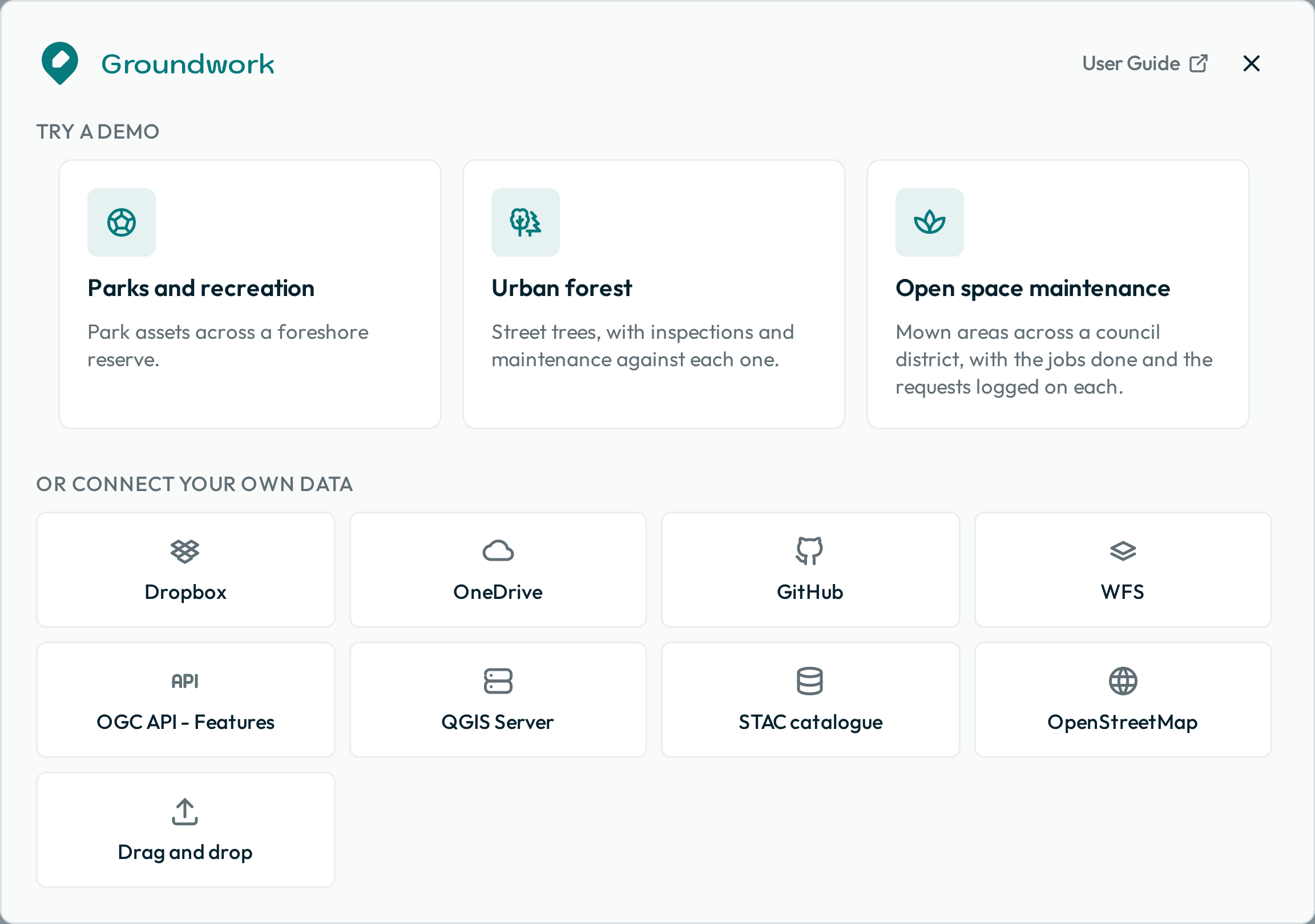
Groundwork names the map for you. Until the map connects, its name is New map. Groundwork then names it after its source:
- For a published folder, Groundwork uses the name of its project file.
- For a QGIS project opened from this device, it uses the title of the project.
- For a GitHub folder published without a project file, it uses the name of the folder.
- If you added exactly one layer, it uses the name of that layer.
- If you added several layers, it uses the address of the service.
Groundwork makes a name from a file, a project title or a layer tidier. For example, street_trees.geojson gives a map called Street trees. Groundwork does not change the names of the layers.
For a Dropbox or OneDrive folder published without a project file, Groundwork uses the host of the share link. The share link does not include the folder name. You can rename the map at any time with Rename in the settings menu.
Cloud folders
This source is a folder in Dropbox, OneDrive or SharePoint that holds a QGIS project and its data files. Start with this source. It needs no server, and a QGIS project holds symbology, labels and display fields that a server interface cannot express. Folder editors who sign in can save changes to the shared data.
Prepare data in QGIS tells you how to make the project. Publish to a cloud folder tells you about the folder layout, the sharing, and what you lose with a folder of GeoJSON files and no project.
GitHub
This source is a folder in a public GitHub repository. The folder holds a QGIS project and its data files, or only GeoJSON files. Paste one of these addresses: the repository’s address, a folder in it, the .qgs file, or a raw.githubusercontent.com address for that file. Nobody signs in, so a public repository opens for anyone who has the link.
If your team must capture data, use a Dropbox folder. Groundwork cannot save changes to a repository. The editing tools still show, but Groundwork refuses the save and lets you download the change.
WFS
This source is a WFS endpoint. Paste the server URL to see a list of the layers that the server advertises. The list has a filter box, and you can choose several layers at once. Groundwork loads the layers live from the server. If the server supports transactions, Groundwork writes your team’s edits directly to the server. Each time the map opens, Groundwork loads the same layers that you chose.
If a layer is too large to load completely, Groundwork loads only the part in the current map view. If the view also has too many of its features, Groundwork adds the layer with no features. A notice then asks you to zoom in and press the layer’s refresh button.
If saves to a WFS layer fail because the server’s data is locked, decrease the number of people or servers that write to it at the same time. If the server keeps that data in a GeoPackage, use a single server instead of several copies. Or move the layers that people edit to PostGIS.
OGC API - Features
OGC API - Features is the newer standard that follows WFS. Paste one of the addresses that the service publishes: its landing page or its collections address. Groundwork finds the other address. Then it lists the collections, with a filter box. Each time the map opens, Groundwork loads the same collections that you chose.
There are two kinds of collection, and you can choose both:
- Features: Groundwork makes an ordinary layer of points, lines or polygons. A small collection loads completely. A larger collection loads only in the current map view, so zoom in to load it.
- Imagery: the list marks these collections
Tiles. Groundwork draws an image from the service’s own map tiles. The image has no feature list, and you cannot select or edit anything in it. The service sets how it looks, so styling that you set in Groundwork does not apply to it.
Both kinds show a padlock. Groundwork can only read from this kind of service, so you cannot edit either kind. The list also shows each collection that publishes neither kind, and the service’s own index of its datasets. These show the reason beside them, and you cannot choose them.
QGIS Server
This source is a QGIS Server project URL, such as http://your-server/qgis?map=/projects/street-trees.qgs. Groundwork reads the project’s layers and their styling almost as it reads them from a folder. Each time the map opens, Groundwork loads the full current project again. So a layer that you add to the project later shows for your team, and nobody must create the map again.
STAC catalogue
This source is a STAC catalogue URL. Groundwork lists the collections that the catalogue advertises. Each time the map loads, Groundwork loads the same collections and items that you chose. If a collection keeps its data in items, it opens to show those items, newest first. Each item that you choose becomes a layer. The format beside each entry sets what your team can do with it:
- GeoJSON: your team can edit it. But a published catalogue has no place to save the edits, so Groundwork saves them only on the device that made them.
- GeoParquet and FlatGeobuf: these show a padlock, and your team cannot edit them.
- PMTiles and COG: Groundwork draws these as an image of the data. There is no feature list, and your team cannot select or edit anything.
- WFS: this works like any other WFS layer. Groundwork saves edits to its server if the server allows it.
OpenStreetMap
Groundwork imports features from OpenStreetMap for a theme, such as bus stops or street lamps. You set the area when you create the map. Each time the map loads, Groundwork imports the theme again over that area.
Before you make a map from a theme, check which features the theme includes. Groundwork imports only point features. So it does not import a park, a cemetery or a school ground that OpenStreetMap shows as an outline.
Drag and drop
Drop files directly, or click to find them on your device. You can add GeoJSON data, a QGIS project with its data files, or .sld style files. You can also paste the address of a GeoJSON file on the web. To add files as layers to an open map, drop them on the map at any time.
To share this data with a team, publish it to a cloud folder. Groundwork stores files that you add in this way only in the browser that opened them, and a share link cannot include them. See what a link leaves behind.
Basemaps
Every map has two basemaps behind your data: a street map and aerial imagery. You do not choose them. Your team changes between the two with the control at the bottom of the map.
Next: Prepare data in QGIS. If your source is already ready, go to Configure the map.